Bidar district is an administrative district located in the northeastern corner of the state of Karnataka, India. It forms part of the Kalyana-Karnataka region (formerly Hyderabad-Karnataka) and is the northernmost district of the state. The district headquarters is the historic city of Bidar, which served as the capital of the Bahmani Sultanate and later the Barid Shahi dynasty during the medieval period.
Key facts
| Attribute | Detail |
|---|---|
| State | Karnataka |
| Region | Kalyana-Karnataka |
| Headquarters | Bidar |
| Country | India |
| Official language | Kannada |
| Type | Revenue district |
Geography
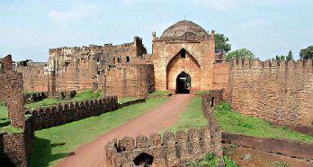
Bidar district lies on the Deccan Plateau and is bounded by the state of Telangana to the east and south, and Maharashtra to the north and west. Within Karnataka, it adjoins Kalaburagi district to the south-west. The terrain is largely a laterite plateau with red and black soils, drained by tributaries of the Manjira and Karanja rivers, both part of the Godavari basin. The plateau is fringed by escarpments that contributed to the strategic siting of Bidar Fort.
Administration
The district is administered by a Deputy Commissioner and is part of the Kalaburagi Revenue Division. It is divided into several taluks, including Bidar, Humnabad, Bhalki, Aurad, Basavakalyan, and newer taluks created during subsequent reorganisations such as Hulsoor, Chitguppa, and Kamalnagar. Local self-government is exercised through the Bidar Zilla Panchayat along with taluk panchayats and gram panchayats.
History
The region around Bidar has a long recorded history extending from the early Chalukyas of Badami and the Rashtrakutas through the Kalyani Chalukyas and the Kakatiyas. Basavakalyan, in the district, was the 12th-century capital of the Western Chalukyas and is closely associated with the social reformer Basavanna and the Lingayat movement.
In 1347, the area came under the Bahmani Sultanate, and Sultan Ahmad Shah I Wali shifted the Bahmani capital from Gulbarga to Bidar around 1429–1430. After the fragmentation of the Bahmani state, Bidar became the seat of the Barid Shahi dynasty until it was annexed by Bijapur in 1619 and later by the Mughals under Aurangzeb in 1656. The region subsequently formed part of the dominions of the Nizam of Hyderabad.
Following the 1948 Police Action that integrated Hyderabad State into the Indian Union, Bidar district was part of Hyderabad State until the States Reorganisation Act, 1956, when Kannada-speaking areas including Bidar were merged with the then Mysore State, which was renamed Karnataka in 1973.
Economy
The economy of Bidar district is predominantly agrarian. Major crops include sugarcane, pulses (notably tur/red gram), oilseeds, jowar, wheat, and pigeon pea, supported by both rain-fed cultivation and irrigation from the Karanja project and other minor tanks. Industrial activity is concentrated around Humnabad, Kolhar and Bidar, with units in food processing, sugar, and engineering. The district is also known for the traditional metal craft of Bidriware, which has been recognised with a Geographical Indication tag.
Transport
Bidar is connected by rail to Hyderabad and Bengaluru and lies on National Highways linking it to Hyderabad, Solapur, and Hubballi. The Bidar Airport, originally a defence airfield of the Indian Air Force, has hosted limited civil operations. The Air Force Station at Bidar is a major training base for fighter pilots.
Culture and heritage
Bidar