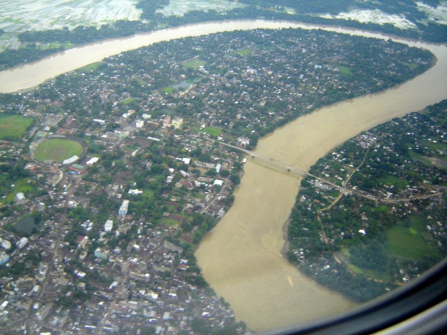
Cachar district is an administrative district in the southern part of the state of Assam in north-eastern India. Its headquarters is the town of Silchar, which is also the principal urban centre of the Barak Valley region. The district forms part of the Barak Valley division along with Hailakandi and Karimganj districts.
Key facts
| Country | India |
|---|---|
| State | Assam |
| Region | Barak Valley |
| Headquarters | Silchar |
| Division | Barak Valley division |
| Type | District |
Geography
Cachar lies in the Barak Valley, a plain drained by the Barak River and its tributaries. The district is bordered by the North Cachar Hills (Dima Hasao) to the north, the state of Manipur to the east, the state of Mizoram to the south, and Hailakandi district to the west. The terrain is largely alluvial, fringed by low hill ranges, and the climate is humid sub-tropical with heavy monsoon rainfall.
History
The name "Cachar" is historically associated with the Kachari kingdom, whose later rulers shifted their capital southwards to Khaspur in the present-day district. After the death of the last Kachari king Govinda Chandra, the territory was annexed by the British and brought under direct administration in 1832, becoming a district of British India. Following the partition of Sylhet in 1947, Cachar received a substantial influx of Bengali Hindu refugees, which significantly altered its demography.
The district originally covered a much larger area. Karimganj was incorporated after Partition, and over time the district was reorganised: the North Cachar Hills were separated to form a distinct unit, and in 1989 Hailakandi was carved out as a separate district. The remaining plains area constitutes the present Cachar district.
Language and culture
Cachar is one of the districts of Assam where Bengali is the predominant language and serves as an official language for administrative purposes in the Barak Valley, alongside Assamese at the state level. The 19 May 1961 Bengali Language Movement, in which eleven persons were killed in police firing at Silchar railway station, is a defining episode in the cultural history of the district and is commemorated annually as Bhasha Shahid Divas.
The population includes Bengali Hindus and Muslims, Manipuris, Dimasa Kacharis, Bishnupriya Manipuris, tea-garden communities of Adivasi origin, and smaller groups of Nagas, Hmars and Khasis. Hinduism and Islam are the major religions practised.
Economy
The economy is based on paddy cultivation in the Barak plains, tea production, fisheries, and small-scale trade. Cachar has a number of tea estates, and Silchar functions as the commercial, educational and transport hub of southern Assam. The district is connected by National Highway 6 (formerly NH-54) and by rail through Silchar Junction, while Silchar Airport at Kumbhirgram provides air links to Kolkata, Guwahati and other cities.
Administration
The district is administered by a Deputy Commissioner and is divided into sub-divisions and revenue circles, with Silchar serving as the sadar sub-division. Civic administration in the headquarters is handled by the Silchar Municipal Board. The district sends representatives to the Assam Legislative Assembly and forms part of the Silchar Lok Sabha constituency.
Education
Major institutions located in or near Silchar include Assam University, a central university established in 1994, the National Institute of Technology, Silchar, the Silchar Medical College and Hospital, and Cachar College, among other affiliated colleges and schools.
Significance
Cachar is significant as the gateway to the Barak Valley and as a cultural and linguistic bridge between the Brahmaputra Valley, the southern hill states, and the wider Bengali-speaking world of eastern South Asia. Its history of plains–hills interaction, its role in the 1961 language movement, and its concentration of higher-education institutions give it a distinct identity within Assam.